
-
Get the news delivered directly to your phone. Click here to Join our WhatsApp Group
(AccuWeather) — Tropical Storm Tammy developed in the central Atlantic on Wednesday evening, becoming the 19th named storm of the 2023 Atlantic hurricane season. AccuWeather forecasters say that it will impact the islands in the northeastern Caribbean as a strengthening hurricane and has an outside chance to become a major hurricane — Category 3 or greater — as it pulls away from the islands next week.
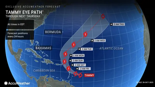
AccuWeather experts have warned for days of a high chance of development into a tropical storm, and on Wednesday morning, dubbed the system a tropical rainstorm and initiated a track map to raise public awareness of the risk to lives and property. AccuWeather’s team of meteorologists expects Tammy to reach hurricane intensity as it crosses the Leeward Islands by early Saturday morning. Tammy may then continue to gain strength while passing over the islands this weekend.


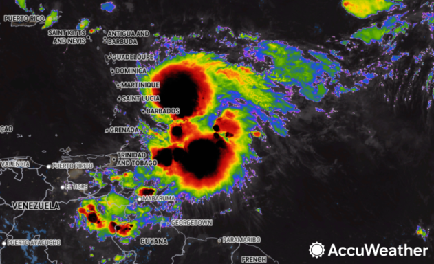
Tammy was packing maximum sustained winds of 60 mph as it spun 100 miles to the northeast of Barbados and 185 miles to the east-southeast of Martinique in the eastern Caribbean as of late Thursday night, according to the National Hurricane Center (NHC). It was moving toward the west-northwest at 8 mph across the central Atlantic.

AccuWeather meteorologists expect Tammy to gain intensity as a tropical system through the weekend and into next week as it encounters atmospheric conditions generally favorable for sustaining a cyclone. Waters are very warm in the region, with sea-surface temperatures in the 80s F, and disruptive winds at mid-levels of the atmosphere, known as wind shear, are minimal.
Steering winds will continue to direct Tammy to the west, similar to the track that former Tropical Storm Sean followed last week. Into the weekend, an area of high pressure across the northern Atlantic will be the main factor behind steering flow across the basin. After Tammy moves near the Leeward Islands in the northeastern Caribbean over the weekend, it will turn more toward the north and then northeast by early next week.
However, Tammy was already tracking farther south than Sean did, and that means impacts from drenching showers and gusty thunderstorms are more likely in the eastern Caribbean, unlike with Sean.

Caribbean impacts from Tammy
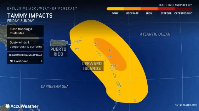
AccuWeather meteorologists have rated Tropical Storm Tammy as “1” on the AccuWeather RealImpact™ Scale for Hurricanes, which is a six-point scale ranging from “less than one” and 1 to 5. There is the likelihood of heavy rain, which could lead to incidents of flash flooding, mudslides and washouts in the Lesser Antilles, especially across the Leeward Islands of the northeastern Caribbean from Friday to Sunday.
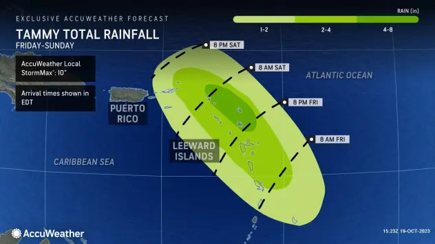
The core of the heaviest rain may be rather small as Tammy is likely to become more compact over the next few days. However, a pocket where 4-8 inches of rain may fall with an AccuWeather Local StormMax™ of 10 inches can occur in the northeasternmost islands.
Wind gusts of 40-80 mph are likely in the Leeward Islands. Power outages and downed trees are possible with winds of that magnitude.
The AccuWeather Local StormMax™ wind gust in the Leeward Islands is predicted to be 100 mph, which is Category 2 hurricane intensity. At this level, property damage to poorly constructed homes and businesses may occur.
The strengthening winds will raise seas in the region, which will not only be a hazard for swimmers due to rip currents but also for fishing and other craft in the region.
The 2023 Atlantic hurricane season thus far
The 2023 Atlantic hurricane season has been busy so far with 19 named storms in the books. There is about 40 days remaining of the official season, which ends on Nov. 30. This season has been above the historical average regarding the number of tropical storms. Only 14 named storms develop across the basin during an average hurricane season.
Six of the named storms so far in 2023 became hurricanes, and three strengthened into major hurricanes, which are at least Category 3 storms with sustained winds of 111 mph or higher. Hurricane Lee, which reached Category 5 strength with winds of 165 mph over the central Atlantic, was the strongest of the season to date. It delivered torrential rain and pounding surf across parts of New England and Atlantic Canada in mid-September.

Tropical Atlantic outpacing development in East Pacific
The Atlantic has been outpacing the East Pacific regarding tropical development, which is rather unusual for an El Niño year. As of Wednesday evening, the Atlantic has had three more storms, including named and unnamed systems and subtropical storms, than the Pacific. An El Niño phenomenon occurs when water temperatures in the central and eastern Pacific near the equator climb above historical averages for months at a time.
The El Niño pattern typically favors more tropical activity in the eastern Pacific due to warm ocean water, which acts as fuel for tropical systems, and it can also suppress tropical development at times over the Atlantic due to an increase in the frequency of disruptive wind patterns over the basin.
From 1971 to 2020, there were 16 hurricane seasons in an El Niño pattern, and of those, only three generated more storms in the Atlantic than in the East Pacific: 1972, 1976 and 1977. It has been 46 years since that occurred, according to AccuWeather Senior Meteorologist and Manager of Forecasting Technology Michael Doll.
The eastern Pacific has been on a hot streak of late, however. Norma recently became the second Category 4 hurricane to form during October on Thursday and is forecast to strike Mexico. Lidia hit Mexico as a Category 4 hurricane on Oct. 10.
Аdvеrtіѕе wіth thе most visited news site in Antigua and Barbuda ~ Wе оffеr fullу сuѕtоmіzаblе аnd flехіblе dіgіtаl mаrkеtіng расkаgеѕ. Yоur соntеnt іѕ dеlіvеrеd іnѕtаntlу tо thоuѕаndѕ оf uѕеrѕ іn Antigua аnd аbrоаd via our One Signal push notifications! Соntасt uѕ аt [email protected].
———————————————————————
-
Get the news delivered directly to your phone. Click here to Join our WhatsApp Group
Make a donation to help support ABN, via PayPal: [email protected]. Follow Antigua Breaking News on X, formerly Twitter @ABNAntigua, and Instgram @AntiguaBreakingNews and on Facebook. Send us a message on WhatsApp at 1-868-704-9864 or email us at [email protected].
JOIN OUR WHATSAPP GROUP FOR NEWS UPDATES: CLICK HERE.
JOIN OUR WHATSAPP GROUP FOR NEWS UPDATES: CLICK HERE.
JOIN OUR WHATSAPP GROUP FOR NEWS UPDATES: CLICK HERE.
JOIN OUR WHATSAPP GROUP FOR NEWS UPDATES: CLICK HERE.
JOIN OUR WHATSAPP GROUP FOR NEWS UPDATES: CLICK HERE.
JOIN OUR WHATSAPP GROUP FOR NEWS UPDATES: CLICK HERE.
JOIN OUR WHATSAPP GROUP FOR NEWS UPDATES: CLICK HERE.
JOIN OUR WHATSAPP GROUP FOR NEWS UPDATES: CLICK HERE.
JOIN OUR WHATSAPP GROUP FOR NEWS UPDATES: CLICK HERE.
JOIN OUR WHATSAPP GROUP FOR NEWS UPDATES: CLICK HERE.
JOIN OUR WHATSAPP GROUP FOR NEWS UPDATES: CLICK HERE.
JOIN OUR WHATSAPP GROUP FOR NEWS UPDATES: CLICK HERE.