
-
Get the news delivered directly to your phone. Click here to Join our WhatsApp Group
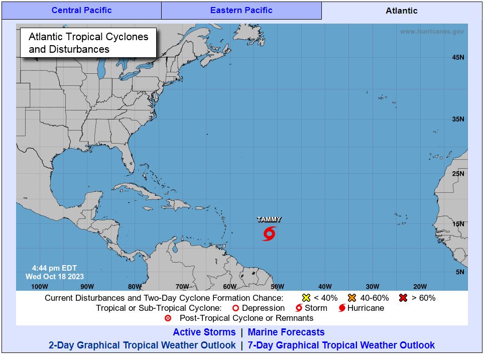
..TROPICAL STORM TAMMY FORMS EAST OF THE WINDWARD ISLANDS…
…TROPICAL STORM WATCHES ISSUED FOR PORTIONS OF THE LESSER
ANTILLES…
SUMMARY OF 500 PM AST…2100 UTC…INFORMATION
———————————————-
LOCATION…13.0N 51.7W
ABOUT 625 MI…1005 KM E OF THE WINDWARD ISLANDS
MAXIMUM SUSTAINED WINDS…40 MPH…65 KM/H
PRESENT MOVEMENT…W OR 275 DEGREES AT 23 MPH…37 KM/H
MINIMUM CENTRAL PRESSURE…1007 MB…29.74 INCHES


WATCHES AND WARNINGS
——————–
CHANGES WITH THIS ADVISORY:

The government of Barbados has issued a Tropical Storm Watch for Barbados. The government of Dominica has issued a Tropical Storm Watch for Dominica. The government of France has issued a Tropical Storm Watch for Martinique and Guadeloupe.
SUMMARY OF WATCHES AND WARNINGS IN EFFECT:
A Tropical Storm Watch is in effect for…
* Barbados
* Dominica
* Martinique and Guadeloupe

A Tropical Storm Watch means that tropical storm conditions are possible within the watch area, generally within 48 hours.
Additional watches and warnings will likely be required later tonight or on Thursday.
For storm information specific to your area, please monitor products issued by your national meteorological service.
DISCUSSION AND OUTLOOK
———————-
At 500 PM AST (2100 UTC), the center of Tropical Storm Tammy was located near latitude 13.0 North, longitude 51.7 West. Tammy is moving toward the west near 23 mph (37 km/h). A westward motion at
a slower forward speed is expected through Thursday. A turn toward the west-northwest is forecast by Thursday night, followed by a turn toward the northwest Friday night or Saturday. On the forecast
track, the center of Tammy will move near or over the Leeward Islands Friday and Saturday.
Maximum sustained winds are near 40 mph (65 km/h) with higher gusts. Gradual strengthening is forecast during the next couple of days.
Tropical-storm-force winds extend outward up to 140 miles (220 km) to the northeast of the center.
The estimated minimum central pressure is 1007 mb (29.74 inches).
HAZARDS AFFECTING LAND
———————-
Key messages for Tammy can be found in the Tropical Cyclone
Discussion under AWIPS header MIATCDAT5 and WMO header WTNT45 KNHC
and on the web at hurricanes.gov/text/MIATCDAT5.shtml
WIND: Tropical storm conditions are possible within the watch area beginning on Friday.

RAINFALL: Through Saturday night, Tammy is expected to produce storm total rainfall of 3 to 6 inches, with maximum amounts of 10 inches, across portions of the northern Windward into the Leeward
Islands. Rainfall totals of 1 to 2 inches with maximum amounts of 4 inches are expected for the British and U.S. Virgin Islands into eastern Puerto Rico. These rains may produce isolated flash and
urban flooding, along with isolated mudslides in areas of higher terrain.
SURF: Swells generated by Tammy will begin affecting portions of the Lesser Antilles on Thursday. These swells are likely to cause life-threatening surf and rip current conditions. Please consult
products from your local weather office.
NEXT ADVISORY
————-
Next complete advisory at 1100 PM AST.
$$
Forecaster Berg
Аdvеrtіѕе wіth thе most visited news site in Antigua and Barbuda ~ Wе оffеr fullу сuѕtоmіzаblе аnd flехіblе dіgіtаl mаrkеtіng расkаgеѕ. Yоur соntеnt іѕ dеlіvеrеd іnѕtаntlу tо thоuѕаndѕ оf uѕеrѕ іn Antigua аnd аbrоаd via our One Signal push notifications! Соntасt uѕ аt [email protected].
———————————————————————
-
Get the news delivered directly to your phone. Click here to Join our WhatsApp Group
Make a donation to help support ABN, via PayPal: [email protected]. Follow Antigua Breaking News on X, formerly Twitter @ABNAntigua, and Instgram @AntiguaBreakingNews and on Facebook. Send us a message on WhatsApp at 1-868-704-9864 or email us at [email protected].
JOIN OUR WHATSAPP GROUP FOR NEWS UPDATES: CLICK HERE.
JOIN OUR WHATSAPP GROUP FOR NEWS UPDATES: CLICK HERE.
JOIN OUR WHATSAPP GROUP FOR NEWS UPDATES: CLICK HERE.
JOIN OUR WHATSAPP GROUP FOR NEWS UPDATES: CLICK HERE.
JOIN OUR WHATSAPP GROUP FOR NEWS UPDATES: CLICK HERE.
JOIN OUR WHATSAPP GROUP FOR NEWS UPDATES: CLICK HERE.
JOIN OUR WHATSAPP GROUP FOR NEWS UPDATES: CLICK HERE.
JOIN OUR WHATSAPP GROUP FOR NEWS UPDATES: CLICK HERE.
JOIN OUR WHATSAPP GROUP FOR NEWS UPDATES: CLICK HERE.
JOIN OUR WHATSAPP GROUP FOR NEWS UPDATES: CLICK HERE.
JOIN OUR WHATSAPP GROUP FOR NEWS UPDATES: CLICK HERE.
JOIN OUR WHATSAPP GROUP FOR NEWS UPDATES: CLICK HERE.